
As severe weather season blankets Texas, residents must stay vigilant and informed. Thunderstorms, often a hallmark of spring in the Lone Star State, can escalate quickly. Familiarizing yourself with the various cloud formations can significantly enhance your ability to anticipate and respond to severe weather.
Thunderstorm Days in Texas
Texas is renowned for its dramatic weather patterns, and thunderstorms are a prominent feature of this climate. Each year, different regions of the state experience varying numbers of thunderstorm days. North, South-Central, and East Texas typically see between 30 and 50 storm days annually. The Southeast, with its coastal proximity, leads the count with roughly 50 to 60 days, while West Texas enjoys a more moderate range of 20 to 40 days each year.
The Formation of Cumulonimbus Clouds
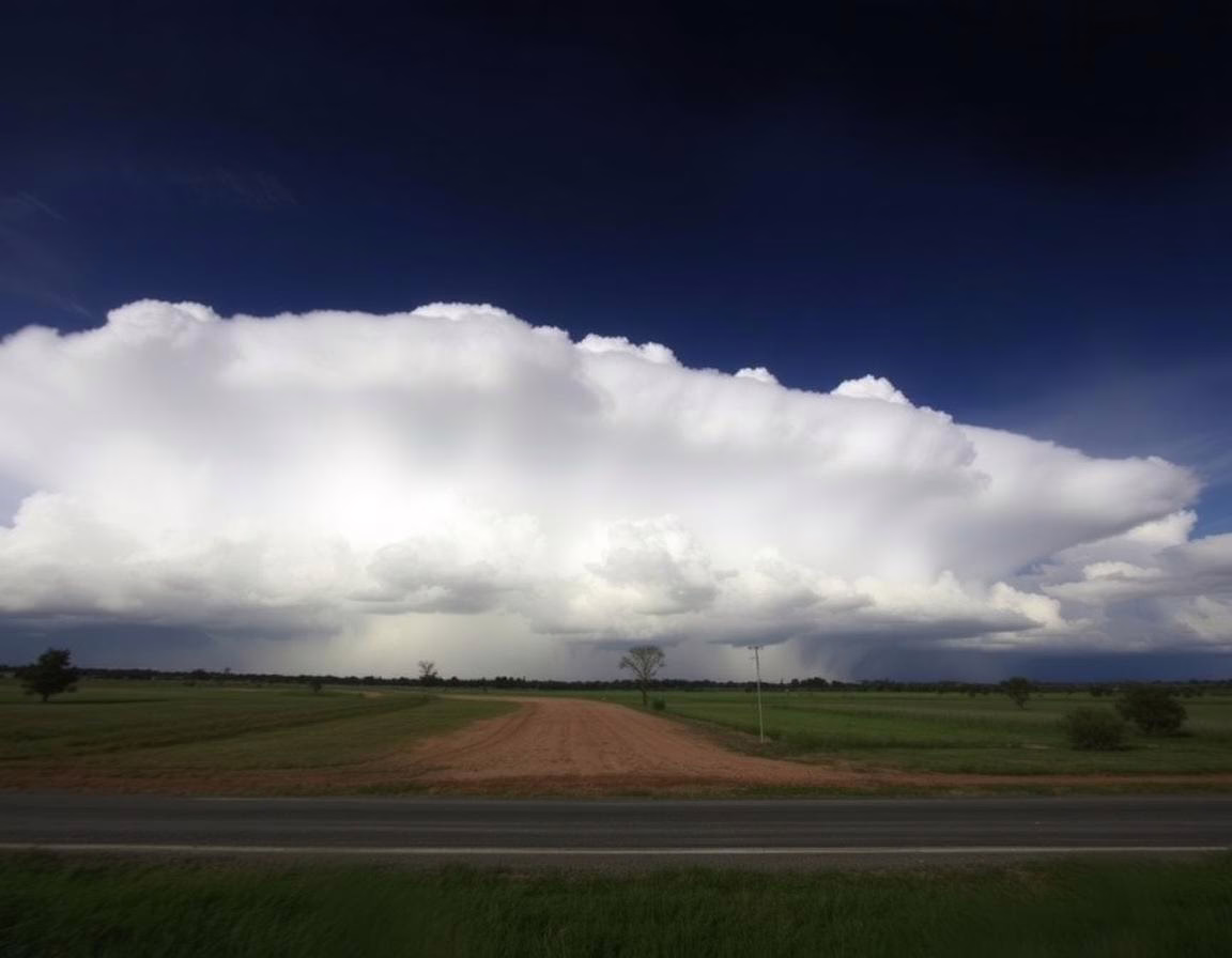
Central to understanding thunderstorms is the formation of cumulonimbus clouds, known as “heaping rain clouds.” These towering giants arise when the atmosphere holds enough instability, moisture, and an upward force. As conditions align, powerful updrafts allow these clouds to soar from 2,000 feet to staggering heights of 40,000 to 60,000 feet, surpassing the cruising altitude of many aircraft.
Within the depths of these clouds, water droplets and ice particles collide, creating an electrical charge. As this charge discharges, it produces the familiar flash of lightning and the booming sound of thunder. This dynamic interplay signifies that the storm has reached its mature stage, where intense updrafts and downdrafts lead to heavy rainfall and strong winds. If conditions intensify, the thunderstorm may evolve into a supercell, capable of persistent rotation and severe phenomena like tornadoes, damaging winds, hail, and torrential rains.
The Life Cycle of a Thunderstorm
As a thunderstorm progresses, it transitions through distinct phases. Initially, vigorous updrafts dominate, pulling warm, moist air into the storm. However, as the storm matures, downdrafts become stronger, leading to a decline in the storm’s energy. Ultimately, without the supportive updraft, the thunderstorm weakens and dissipates.
Recognizing Cloud Types
The strength and severity of a thunderstorm can often be gauged by the types of clouds forming within it.
Anvil Clouds
Anvil clouds form at the peak of a mature thunderstorm. Characterized by their flat, white tops, these clouds spread horizontally once they reach the stratosphere. Strong winds at high altitudes can flatten the cloud tops, making anvil clouds visible from over 100 miles away.
An overshooting top may accompany these clouds, indicating a vigorous updraft pushing through the anvil into the lower stratosphere. This feature provides a visual cue of the storm’s intensity.
Wall Clouds
Underneath the rain-free base of a thunderstorm, wall clouds can develop if the storm is particularly strong. These low-hanging, rotating formations appear where warm, moist air is drawn upward, indicating significant updraft activity. Wall clouds are critical indicators for spotting potential funnel clouds or tornadoes.
Funnel Clouds
Funnel clouds are extensions of wall clouds, characterized by their rotating column of air that descends from the cloud base. Unlike tornadoes, funnel clouds do not make contact with the ground. If a funnel cloud does touch down, it becomes classified as a tornado, a powerful and hazardous weather phenomenon.
The Mystery of Green Clouds
On occasion, clouds may take on an otherworldly green hue, signaling an impending severe storm. This coloration results from a high concentration of hail within the clouds. The scattering of blue light waves by hail particles, combined with sunlight, can create this striking visual effect. While green clouds can be alarming, recognizing their significance can prepare residents for the possibility of severe weather.
Weather Preparedness
Understanding these cloud formations empowers Texans to respond proactively to changing weather conditions. Observing the sky and recognizing signs of severe storms can be life-saving. A well-informed public can take necessary precautions, ensuring safety in the face of nature’s fury.
Key Takeaways
- Texas experiences a wide range of thunderstorm days each year, with Southeast Texas having the highest frequency.
- Cumulonimbus clouds are the primary indicators of severe weather, often leading to thunderstorms and supercells.
-
Recognizing cloud formations like anvil clouds, wall clouds, and funnel clouds can provide critical clues about storm intensity and potential tornado activity.
-
Green clouds signal the presence of hail and indicate the likelihood of severe weather.
In summary, knowledge is power when it comes to weather preparedness. By understanding cloud formations and their implications, Texans can better navigate the challenges of severe weather and protect themselves and their communities.
Read more → www.statesman.com